 See images of the Canal at work. |
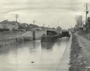
The Erie Canal crosses New York State from east to west, from the Hudson River to Lake Erie. It wasn’t the first canal built in New York, but it was the most successful government–building project in the nineteenth century. The Canal followed a path created by nature and glaciers that changes 573 feet in elevation from Albany to Lockport. To address this change in elevation, eighty–three locks were built that raised or lowered boats up to fifteen feet at a time, and eighteen aqueducts were constructed to carry the canal over rivers and valleys. Along the way, builders knew that the level of the Canal had to be below Lake Erie so that the lake water would help to fill the Canal. Unlike many of the earlier structures that were made of wood, the Erie Canal was built of stone and iron so that it would last. The main part of the original canal was only four feet deep and forty feet wide. It was built in three sections, beginning with the middle section first. The sections to the east and to the west were then built and the entire canal was completed in 1825. |
|
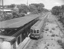 See images of how travel on the Canal changed. |
When construction on the canal began in 1817, merchandise from New York City could take several weeks to travel to western New York. These goods would be loaded and unloaded onto wagons and boats, and bounce along dusty, dirt roads. Many different foods and supplies were not shipped at all because they could not survive the trip. The canal changed all of this. Trade, businesses, and communities grew along the Erie Canal because it became much easier to send freight and people across the state. |
|
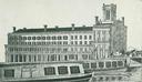 See images of people and services that grew along the Canal. |
Rochester and the area around it looked very different after the Erie Canal reached here in 1823. When digging on the Canal in Rochester began in 1821, there were about 1500 people in the small village. The falls in the Genesee River powered the early mills that exported 26,000 barrels of flour in 1818. After the Erie Canal opened, this number rose quickly - to 200,000 barrels in 1828, and then to 500,000 by 1838. Rochester's population and businesses grew so quickly it became the first “boomtown,” like the later frontier towns in the west. By 1834, Rochester was an established city. |
|
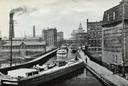 See images of new and expanded industries along the Canal. |
The Erie Canal made New York the Empire State, and it made Rochester one of the state's leading cities. Here you can see and read about the changes the Canal brought in business, trade, travel, and everyday life. You can also explore how the Canal worked, and how the lives of people along its path changed. Carolyn Vacca, Monroe County Historian |
|