|
 |
|
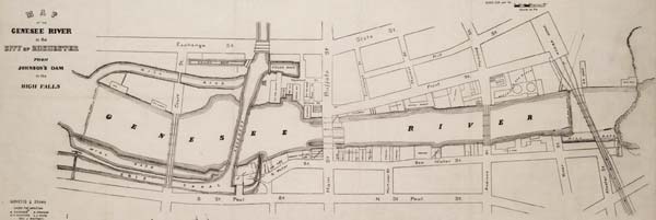
Can you find the Erie Canal aqueduct that went over the river? Use your mouse to
point to it in the picture. (Go slowly and watch for the
clue.) Do you know what an aqueduct is? Use your mouse to find the Main Street bridge. (Again, go
slowly and watch for clues). Is the bridge like the aqueduct? Would you like to take a closer look at the map (209 KB, 3520 x 1184 pixels)? |
From: Map of the Genesee River in the city of Rochester from Johnson's Dam to the High Falls, 1866. Printed pen and ink drawing including sketches of Main St. Bridge and Aqueduct. 14" x 23 1/2". Can you find the water fall on the river? |
|