Digital Collections -> Pathfinders -> Maps-> Early Rochester Mapmakers

Early Rochester Mapmakers


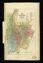
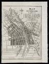
The works of two local mapmakers are found in the map collections. They are Silas Cornell and Elisha Johnson. Here are some biographical facts about them:
 

Silas Cornell (1789-1864)

Was a nationally known map and globe maker, as well as a surveyor and civil engineer.
Cornell's Map of the City of Rochester, 1855
Married Sarah Mott (1791-1872) in 1815.
Moved to a farm about four miles northwest of Rochester in 1823.
In 1836 moved to Rochester and opened a survey office.
Was on the committee for the laying out of Mount Hope Cemetery.
Was elected vice-president of the Rochester Anti-Slavery Society when it was organized in 1838.
Was a devout Quaker.
In 1845 received a patent for a mounting globe.
Sons Frederick James Mott Cornell and Thomas Clapp Cornell were also engineers.
Died in Rochester in May of 1864.

To see more of Cornell's maps, go to the Basic Search page of Rochester Images and type in Cornell, Silas.
 

Elisha Johnson (1784?-1866)

Was a surveyor, draftsman, contractor and engineer.


Johnson's Map of Rochester, 1834

Was a graduate of Williams College.
Along with James Seymour, bought a plot of land on the east bank of the Genesee River, which came to be known as the Johnson & Seymour Tract. It was annexed by Rochester in 1823.
Built the Carthage and Tonawanda Railroads.
Built the Johnson & Seymour Dam on the Genesee River, and also the Johnson & Seymour.
Raceway on the river's east bank to provide water power.
Built the second Main Street Bridge.
Was an engineer of the Genesee Valley Canal.

To see more of Johnson's maps, go to the Basic Search page of Rochester Images and type in Johnson, Elisha.