Beginnings of the Neighborhood
Naming the street
For purposes of our story, the name West Avenue is considered to be part of the road that was originally laid out and named Buffalo Street in 1811 by Colonel Nathaniel Rochester, the city's founder. However, boundaries and street names changed over the years. From approximately 1811 to 1859 Buffalo Street extended from the Main Street Bridge west to the city line. In 1859 a portion of Buffalo Street, from the Erie Canal west to the city line, was renamed West Avenue. In 1871 Buffalo Street was renamed West Main Street. By 1913 West Main Street encompassed the entire stretch of road from the Four Corners to the Chili Avenue and West Avenue split. West Avenue then extended only from York to Cairn Street.
Early settlement
Originally, the land in this area was part of the Town of Gates. The tract was known as the Bush-King Tract. In 1834, the Bush-King Tract became part of the newly incorporated City of Rochester. The area was a hub for the two major types of transportation networks of the 19th century.
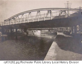
The Erie Canal (completed in 1825) was on the tract's eastern boundary while the Rochester & Tonawanda Railroad (which began service in 1837) was on the northern boundary. West Avenue, always a principal east-west thoroughfare in the city, bisected the tract.
The Erie Canal at West Avenue, as seen in 1903.
The major streets in the neighborhood were laid out by the late 1830's. Madison Park (called Mechanic's Square at the time) was laid out in 1839. Various types of businesses, institutions and settlers came to the neighborhood.
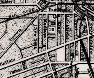
1849 map of area
|Introduction| |Next|
Send comments to Webmaster
Copyright Monroe County (NY) Library System
115 South Ave., Rochester, NY 14604