|
About the Mitigation
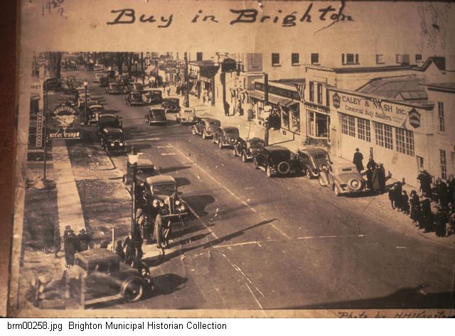
Photos The photograph in the middle
(above) is one in a series of pictures taken by Andy Olenick to document
buildings in the East Avenue/Winton Road area destined to be torn down for
the construction of a new Wegmans Food Markets grocery store. These pictures
were taken in April 2011. Archival black and white versions of these photos
are being stored in the Rochester Public Library Local History Division's
Picture File Collection.
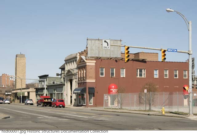
When a construction project is planned, photographs and other tools are used
to assess and
document the various stages of demolition and building. This is done in
order to help mitigate any risks or potential problems that may impede the
project. This information also happens to be helpful to historical
researchers and local historians, who need to document and understand the
past.
In the case of this one city block, over the past almost 200 years there
have been many changes which have been documented through articles, books,
records, maps and photographs.
Early History of the Area From Brighton
Center to Brighton Village
The area began its commercial life as a small hamlet in the Town of
Brighton named "Brighton Center" or "East Brighton." In Landmarks of
Monroe County, New York, William F. Peck gave a brief description of
the hamlet:
| "Brighton village, or as otherwise known, East Brighton, is the larger
and of first importance among the municipalities now existing in the
town. Its location is in the northeast part of the town, on the line of
the Erie canal, and also on the New York Central railroad; and to the
presence of these great thoroughfares of travel and transportation it
owes its prosperity, if not its very existence. The pioneer on the
village site was Thomas Blossom, whose dwelling stood near the southeast
corner. In 1820 Israel Blossom opened a public house, which was burned
in 1867, the year in which the church was destroyed. It is said that a
store was established here in 1816, but it is known that William Perrin
had a store open in 1818. Justus Yale built a store in 1823, where now
stands the Caley & Nash carriage shop, and about the same time Linus
Wilcox also opened a tavern. Ira West was an early storekeeper, and also
proprietor of a distillery in this near vicinity. The post-office was
established in 1817, Dr. James Holden, postmaster. He was succeeded by
Benjamin Blossom, the latter holding office thirty years. The first
mails were brought on horseback from Canandaigua." - From Peck, William
F., Landmarks of Monroe County, New York, 1895 (page 243) |
According to a
Rochester History article by City Historian Blake McKelvey,
Volume 33 Nos. 2 & 3, in the 1830s East Avenue to the
east of Brighton Village was traversed by stage coaches heading to
Rochester. Occasionally
passengers would get off the coaches and embark on canal boats at
Brighton to make the journey
the rest of the way into the city.
.jpg) |
.jpg) |
|
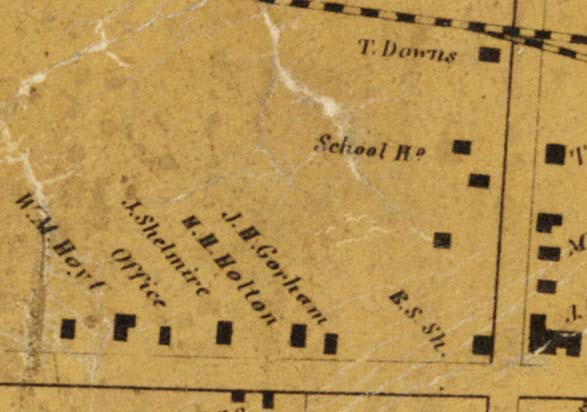
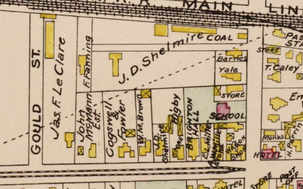
1858 |
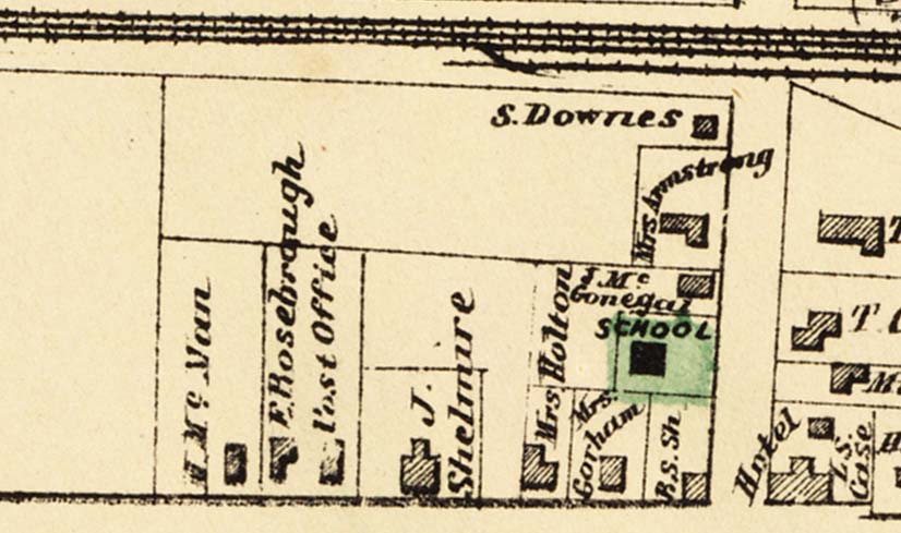
1872 |
Early History of the Area From
Village to City Commercial Hub
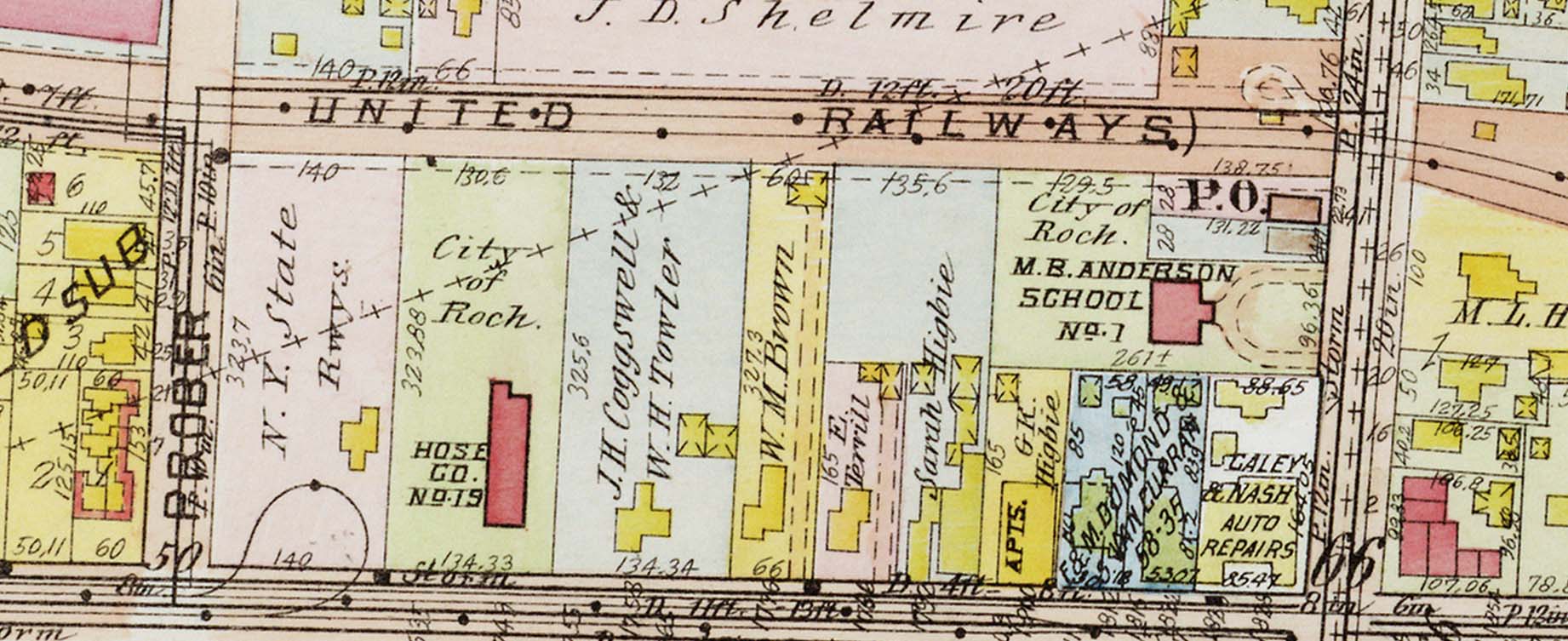
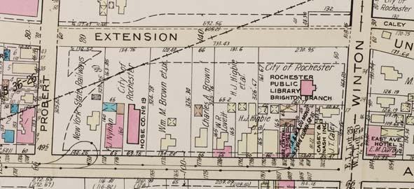
In 1885, the hamlet became incorporated as a village in the Town of
Brighton. As the village grew so did its neighbor to the west, the City
of Rochester. The city's East Avenue residential area was expanding to
the east at the same time commercial and residential growth occurred in
the village, which included houses, a school, a fire house, four hotels
and various stores. The people of the village were served by streetcar
line and the New York Central Railroad. The roadway was given a macadam
surface in 1899, and traffic increased.
Many factors conspired to result in the annexation of this area to the
city in 1905. One of the best accounts of the annexation can be found in
Rochester History, Volume 35, No. 1, written by Joseph Barnes. After
annexation, the city invested in infrastructure (including a new fire
station, Hose Co. No. 19), and new businesses joined old ones.
Planning the First Wegmans on East
Avenue
According to an article in the Rochester Democrat & Chronicle dated
November 15, 1949, Wegmans (an established local food store chain) had
been purchasing land since around 1946 in preparation for building a
supermarket at this location. At that time, plans were to begin
construction the following spring. However, the store did not open until
October, 1962.
Just to the east of this block, many changes were in store with the
construction of the I-490 and I-590 highway system and interchange. Many
buildings to the east and south of the East Avenue/Winton Road
intersection were torn down to make way for the highways. The chaotic
highway interchanges that resulted became known as the "Can of Worms."
The "Can" was eventually reconstructed to become more user-friendly.
.jpg) |
.jpg) |
|
1949 Newspaper Clipping |
| |
.jpg) |
|
Map of Can of Worms area
1972 June 15 |
| |
| |
.gif) |
|
Photo provided by Wegmans
Food Markets, Inc. |
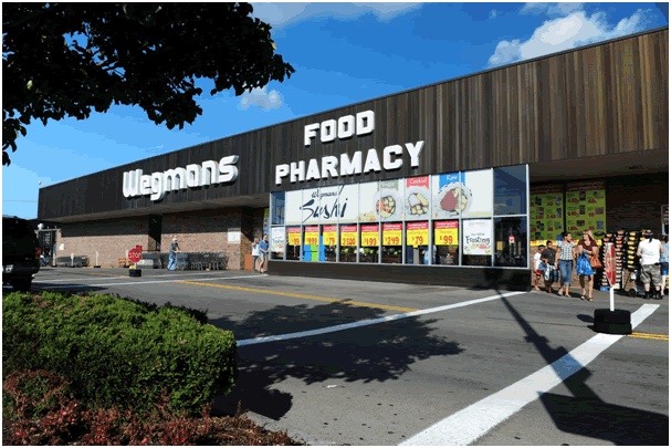
Planning the New Store
An article in the March 24, 2001 Democrat &
Chronicle mentions that "Wegmans Food Markets Inc. has purchased three
parcels of land adjacent to its East Avenue store, but the company says
it has no plans to expand the supermarket, one of the smallest in its
60-store chain." Later in the article, Ralph Uttaro, Wegmans' director
of development, explains that the company has a long-range strategy to
control whatever is next to a store in case it decides to expand at some
future point. The properties purchased around that time included those
located between 1776 and 1804 East Avenue, housing Eastside Gymnastics,
Jacqueline's Suburban Fashions & Bridal and the East Avenue Gift Shop.
Shortly afterwards, the local neighborhood association scheduled a
design charette with Wegmans representatives to address neighborhood
concerns. In planning a project of this scale, the City of Rochester,
local residents and company representatives work together to plan the
best possible outcome for all concerned. When Wegmans purchased the M &
T Bank property on East Avenue in 2009 and announced plans to demolish
their East Avenue store and replace it with a larger structure,
necessitating the demolition of other structures on the street, the
planning began to bear fruit. As part of this process, Andy Olenick
photographed the existing buildings.
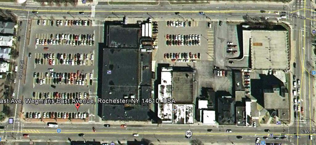
.jpg) |
|
Google Earth Image taken April 29, 2005, showing most buildings
still standing |
| |
| |
.jpg) |
|
Google Earth Image taken May 9, 2011, showing that the buildings to
the east are now gone |
The Collection
Photo Key
Click a number to see the corresponding photo |
.jpg)
|
| |
Photo Collection
Click each image to read more |
| |
|
|
|
.jpg) |
.jpg) |
.jpg) |
.jpg) |
|
1 |
2 |
3 |
4 |
| |
|
|
|
.jpg) |
.jpg) |
.jpg) |
.jpg) |
|
5 |
6 |
7 |
8 |
| |
|
|
|
.jpg) |
.jpg) |
.jpg) |
.jpg) |
|
9 |
10 |
11 |
12 |
| |
|
|
|
.jpg) |
.jpg) |
.jpg) |
.jpg) |
|
13 |
14 |
15 |
16 |
| |
|
|
|
.jpg) |
.jpg) |
.jpg) |
.jpg) |
|
17 |
18 |
19 |
20 |
| |
|
|
|
.jpg) |
.jpg) |
.jpg) |
|
|
21 |
22 |
23 |
|
| |
|
|
|
Postscript
The original store closed for good in February, 2013 in preparation for
its demolition. The new store was already in the process of being built
and scheduled to open in May, 2013. Here are photos taken in March, 2013
that show the old and new buildings as they briefly co-exist.
Bibliography
Rochester Democrat &
Chronicle [Rochester, N.Y.]:
"Wegman's buys half acre of land,"
November 14, 1949.
Bilovsky, Frank, "Wegmans buys East Ave. lots next to store," March 24,
2001.
Liu, Lara Becker, "Eastside neighbors get head start on Wegmans,"
October 30 2001.
Tobin, Tom, "Wegmans plans to build around East Ave. hold out," August
2, 2009.
Rochester History journal:
Barnes, Joseph C., "The Annexation of
Brighton Village,"
Rochester History, Volume 35, No. 1, January 1973.
McKelvey, Blake, "East Avenue's Turbulent History,"
Rochester History, Volume 33, Nos. 2 & 3, April and July, 1966.
Books:
William F. Peck,
Landmarks of Monroe County, New York, Boston : Boston History
Co., 1895.
Rochester City Directories: available at the Local History Division and
online at Rochester
City Directories
Maps and atlases:
Beers, F. W. (Frederick W.). Atlas of
Monroe Co., New York: From Actual Surveys by and under the Direction of
F. W. Beers. New York: F. W. Beers & Co., 1872.
Brown, P. J., Gillette's map of Monroe Co., New York, 1858.
Hopkins, Griffith Morgan. Plat Book of the City of Rochester, New
York: From Official Records, Private Plans and Actual Surveys.
Philadelphia: G. M. Hopkins Co., 1918.
Hopkins, Griffith Morgan. Plat Book of the City of Rochester, New
York: From Official Records, Private Plans and Actual Surveys. Vol. 1.
Philadelphia: G. M. Hopkins Co.,1935.
Plat Book of Monroe County, New York. Philadelphia: J. M. Lathrop
& Co., 1902.
Rochester Images
database
Also, thanks to Wegmans Food Markets, Inc. for the photo of the original
Wegmans store and for information provided.
|